Orekhovsky Nature Reserve: Borders, Lakes and Route Start
Orekhovsky Nature Reserve is the very territory through which the route from Orekhovo station to Ladoga runs. It is its forests, swamps and lakes that you pass through in the first thirty kilometres, before you reach the shore. Below is what this protected area is, where its borders lie and where the route officially begins.
Key Information
The reserve has the status of a state complex nature reserve of regional significance and lies in two districts at once — Priozersky and Vsevolozhsky.
| Parameter | Value |
|---|---|
| Status | complex nature reserve of regional significance |
| Districts | Priozersky and Vsevolozhsky |
| Area | ≈ 9048 ha |
| Cadastral file | No. 029 |
| Zoning | none, a single cluster area |
| Representative point | 60.4933963 / 30.3574458 |
| Borders | 60.4313–60.5535 N, 30.2318–30.4155 E |
The word 'cluster' here matters more than it seems: inside the reserve there are no separate zones with different regimes — it is one integral area. That is, the rules are the same both at Orekhovo station and deeper in, closer to Ladoga.
Where the Route Begins
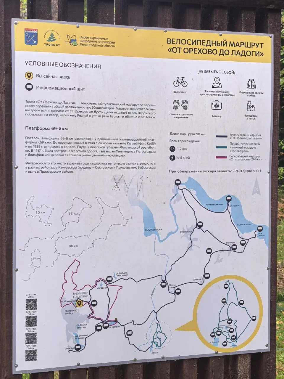
The official starting point of the eco-route 'From Orekhovo to Ladoga' according to the Directorate of Protected Areas of Leningrad Oblast is 60.464110 / 30.262812. This is a two-minute walk from Orekhovo station, where the commuter train from Finlyandsky railway station arrives. In fact, the route starts not in the forest but right by the platform: you get off the train, walk through the settlement — and that's it, the dirt road begins.
The full route is about 90 km long, but there are several options in the register, including short segments of 12–30 km. Whether to walk it entirely or split it into parts is a matter of preparation, not accessibility.
What's Inside
- **Lakes.** On the route you encounter Osinovskoye and Shchuchye; both are forest lakes, without infrastructure or equipped beaches.
- **Pine forests and swamps.** The terrain is flat, in places boggy; after rain the lowlands hold water for a long time.
- **Dirt roads.** The main ones are rolled, with sandy surface, but they are crossed by fresh logging tracks.
- **Ladoga shore at the finale.** The route reaches the western shore of Ladoga near Dalnyaya Bay.
How to Get to the Start
| Method | How |
|---|---|
| Commuter train | Finlyandsky railway station → Orekhovo station (Priozersk direction), then on foot |
| Car | along Priozerskoye highway to Orekhovo, then only dirt roads |
| Bicycle | the optimal option: the route is long and the roads are rolled |
The bicycle option also starts from Orekhovo station: the surface here allows you to ride rather than push the bike.
What's Important to Know
- **Visiting rules** are determined by the Directorate of Protected Areas of Leningrad Oblast — check before your trip, especially if you plan to stay overnight.
- **There is no water or shops inside.** Food and water are taken in Orekhovo, Pyatirechye and Zaporozhskoye — these are the last points of civilisation before the forest.
- **Signal is lost in patches.** It is better to have the track and map offline.
- **Return journey.** From the final point of the route (Nikityno platform) commuter trains run — but the schedule must be checked in advance, because the last trains leave in the evening.
Map
- Route start (Orekhovo) — official starting point
- Orekhovo station — commuter train from Finlyandsky railway station
- Osinovskoye lake — forest lake, no beaches
- Shchuchye lake — on the route
- Orekhovsky Nature Reserve — representative point
- Nikityno (69 km) — finish, commuter train back
Reserve borders — according to OSM; official start — according to the Directorate of Protected Areas of Leningrad Oblast. Maps — © OpenStreetMap contributors.
The full 90 km — no. In reality, segments of up to 25–30 km are covered in a day, and the route is divided into parts: for example, from Orekhovo to the lakes or from the lakes to Ladoga.
The reserve itself is a public area with a protected area regime. Restrictions concern parking, campfires and transport, and they should be clarified with the Directorate of Protected Areas of Leningrad Oblast.
First the forest and dirt roads: the first kilometres from the station have almost no views. The lakes begin further on, and the Ladoga shore is already in the final part of the route.
These are different territories and different trips. Orekhovsky lies to the south and stretches towards Ladoga, Vyaryamyanselka — to the north, near the Priozersk direction.
Related
- Route 'From Orekhovo to Ladoga' — 90 km across the Karelian Isthmus: route, transport, photos
- Vyaryamyanselka Ridge — nature reserve, eco-trails, four official entrances
- Nikityno (69 km) — the platform where the route ends: schedule and prices
- Dalnyaya Bay — Banny mole, lighthouse and campsite on the western shore of Ladoga
- Trip photos — 16 shots and 4 videos from the route
Frequently asked questions
Can the reserve be crossed in one day?
The full 90 km — no. In reality, segments of up to 25–30 km are covered in a day, and the route is divided into parts: for example, from Orekhovo to the lakes or from the lakes to Ladoga.
Is a permit needed to visit?
The reserve itself is a public area with a protected area regime. Restrictions concern parking, campfires and transport, and they should be clarified with the Directorate of Protected Areas of Leningrad Oblast.
What comes first — forest or lake?
First the forest and dirt roads: the first kilometres from the station have almost no views. The lakes begin further on, and the Ladoga shore is already in the final part of the route.
How does the reserve differ from the Vyaryamyanselka Ridge?
These are different territories and different trips. Orekhovsky lies to the south and stretches towards Ladoga, Vyaryamyanselka — to the north, near the Priozersk direction.
Route map
- — official starting point
- — commuter train from Finlyandsky railway station
- — forest lake, no beaches
- — on the route
- — representative point
- — finish, commuter train back
Points are from OpenStreetMap. Maps — © OpenStreetMap contributors.